How to read map co-ordinates

New Forest
How to read map co-ordinates
This page will show you how to read map co-ordinates on the Ordnance Survey map excerpts published throughout this New Forest National Park web site.
OS maps use a grid system that divides the country into squares of 100km x 100km, with each square having a two letter reference. The reference for the New Forest area is SU and these letters prefix the numeric grid reference. Each square is then divided into 100 smaller squares, each one representing 10 sq.km.
These 10km dividing lines are numbered from 1 to 9, starting from the bottom left corner of the 100km square, and so increase left to right (‘eastings’) and upwards (‘northings’).
Table of Contents
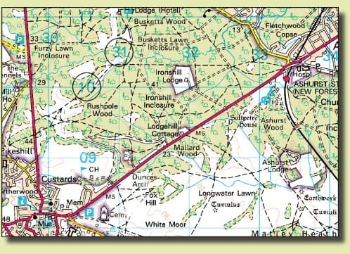
ToggleOn small scale maps, such as the extracts throughout this web site, these 10km squares are divided again into 1km x 1km squares, with the eastings and northings numbered 01 to 99 through each separate 100km square. In the image below, easting 31 and northing 10 are circled to illustrate this:
How to read 6 digit grid references
Each 1km square can be divided further still – in the reader’s mind – into 10 smaller squares, with the dividing lines being numbered 1 to 9 in the same directions (to the right and upwards from the bottom left corner). This smaller ‘mental’ grid, the red lines in the image below, will pinpoint an exact location within the 1km square.

So to find a place using a given grid reference, simply locate the appropriate easting first (the first two digits of the reference) and then the appropriate northing (the 4th and 5th digits). This intersection will be the bottom left corner of the square that you need to divide up in your mind. Then gauge the distance across and up this square in 1/10ths, according to the 3rd and 6th digits of the reference.
Example from the above excerpt: the grid reference for Ashurst railway station is SU334102.
Greater accuracy can of course be achieved by using an 8 digit grid reference. Here, the distances following the 3rd and 6th digits of a 6 digit reference (the red lines above) are divided again into 1/10ths.
Using the same example, the 8 digit grid reference for Ashurst railway station is SU33381012.
© Copyright information – Both map extracts shown on this page, along with all extracts throughout the New Forest National Park website, are Crown Copyright and have been published under License no.WL8732. The extracts cannot be reproduced without consent.

Most Visited Tourist Attractions in UK
The UK has a variety of world-renowned attractions. These range from museums to historic landmarks, and include natural wonders as well. This list includes some of the UK’s most popular tourist attractions, which attract millions of

Family Holiday in UK
The UK offers a wide range of family-friendly activities for all ages. There’s something to do for everyone, whether you want to explore vibrant cities, enjoy the countryside or experience thrilling adventure parks. Here are some of

Attractions in UK
The United Kingdom has a rich history, culture and natural beauty. This diverse and fascinating nation has something to offer everyone, whether you are a history enthusiast, a nature lover, or if you want to experience

Enjoying Nature in the New Forest
Immersing yourself in nature offers peace, adventure, and a unique way to rejuvenate the spirit. With its beautiful surroundings and diverse wildlife, the New Forest is an ideal location for outdoor enthusiasts. Planning your next

Top Road Trip Hacks
For nature enthusiasts, a road trip represents more than just traveling from point A to B—it’s an opportunity to forge meaningful connections with the natural world. Whether you’re planning to explore remote national parks or

Exploring natural wonders
Exploring natural wonders: from New Forest to the deserts of the UAE For English travellers, the UAE is a sweet invitation into a world of exceptional land beauty. From the billowing dunes of its

